

Location & size
The then Kintampo North Municipal was established in 1988 under LI 1480. However, in 2004 the Kintampo South District was carved out from it, and it was renamed the Kintampo Municipal by the Local government Act, Act 462, LI 1762. The Kintampo Municipal is one of the Seven (7) Municipals and among the Twenty-two (22) Municipal/Districts in the BAR of Ghana.
It is located between latitudes 8º45’N and 7º45’N and Longitudes 1º20’W and 2°1’E and shares boundaries with five districts in the Country:, namely; Central Gonja District to the North; Bole District to the West; East Gonja District to the North-East (all in the Northern Region); Kintampo South District to the South; and Pru District to the South- East (all in the Brong Ahafo Region).
The Municipal Capital, Kintampo, is about 130KM away by road from the regional capital and lies east of the BAR Capital, Sunyani. The Municipal has a surface area of about 5,108km², thus occupying a land area of about 12.9% of the total land area of BAR (39,557km²).
In terms of location and size, the municipal is strategically located at the centre of Ghana and serves as a transit point between the northern and southern sectors of the country. It is hoped that the construction of the Kunsu- Ntankro- Prang- Kintampo- Wa roads will further open and enhance vehicular traffic on these roads as well as interaction between the southern and northern parts of Ghana.
Topology & drainage
The Kintampo North Municipal which falls within the Voltain Basin and the Southern Plateau physiographic regions is a plain with rolling and undulating land surface with a general elevation between 60-150m above sea level. The southern Voltain plateau occupying the southern part of the district is characterized by series of escarpments.
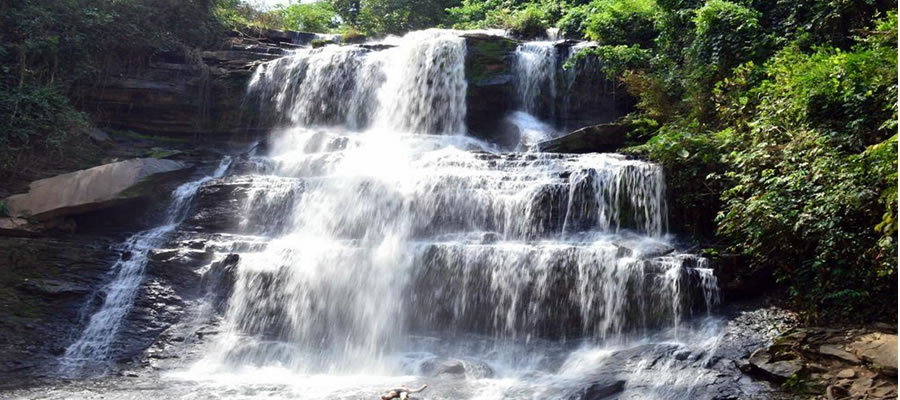
The municipal which falls within the Voltain basin is endowed with a lot of water resources. The major water bodies include the Fra, Urukwain, and the Nyamba rivers. Others are rivers Oyoko, Nante, Pumpum and Tanfi. These water bodies flow through the west of the district and join the Black Volta at Buipe. The slopes through which the rivers flow have given rise to water falls. The major ones include the Fular Falls on the Oyoko River and the Kintampo water falls on the Pumpum River. Most of these rivers are intermittent and the large ones like Urukwain and Pumpum fluctuate in volume. This makes them unreliable for irrigation purpose.
In terms of relief and drainage, the vast expanse of flat land especially the northern part makes it suitable for large scale mechanized farming. Road construction and other activities are also relatively cheap. The vast water resources in the western part of the district could be harnessed for irrigation purposes especially rice cultivation and dry season gardening as well as domestic supply of potable water. Fishing which is already an important activity on the Black Volta can be promoted if measures are put in place to ensure sustainable operations by the fishermen.
Climate & vegetation
Climate
The Municipality experiences the Tropical Continental or interior Savannah type of climate, which is a modified form of the tropical continental or the Wet-semi equatorial type of climate. This is due largely to the fact that the district is in the transitional Zone between the two major climatic regions in Ghana.
The mean annual rainfall is between 1,400mm-1,800mm and occurs in two seasons; from May to July and from September to October with the minor season (May – July) sometimes being obscured. However, because of the transitional nature of the area, the distinction between the two peaks is often not so marked.
The mean monthly temperature ranging from 30°c in March to 24°c in August with mean annual temperatures between 26.5°c and 27.2°c. These conditions give rise to sunny conditions for most parts of the year. Relative humidities are light varying from 90%-95% in the rainy season to 75% - 80% in the dry season. The climate of the district has the tendency to change and be inclined more to the drier tropical continental conditions or to the wet semi-equatorial conditions.
Vegetation
The district comes under the interior wooded savannah or tree savannah. However, owing to its transitional nature, the area does not totally exhibit typical savannah conditions. Thus the savannah here is heavily wooded, though most of the trees are not as tall and gigantic as those in the most deciduous forest.
It is believed that the transitional Zone was once forested and that the savannah conditions currently prevailing have been the result of man’s activities. This may be evidenced by the existence of “fringe forest” found along the banks of major rivers and streams and other areas where the impact of man’s activities are minimal.
Only trees such as the Mahogany, Wawa, Odum, Onyina, Boabab, Dawadawa, Acacia, and the Sheanut trees, which have adapted to this environment are found in the vegetation zone. They are few and scattered except along the margins of the moist deciduous forest where the trees often grow quite close together. Grass grows in tussocks and can reach a height of about 10 ft.
Geology & soil
Geology
The rock formation and type forms the geology of an area. The rocks underlying the Kintampo North Municipal form part of the “Voltarian formation” which covers about two – fifths (2/5) of the surface area of Ghana and about 80% of the District’s land surface. Rocks belonging to this formation are mainly sedimentary and exhibit horizontal alignments.
Sand stone, shale, mudstone and limestone are the principal examples of these rocks. Oral reports revealed that the Voltarian formation was created soon after the Precambrian era when sagging of land occurred resulting in scarp slopes due to different levels of sagging.
The geology of the district is a potential resource for development. As already mentioned, deposits of clay, sand, limestone, stone/gravel and a few reported traces of gold at Kunsu, Sogboi, Bankamba and Dwere could be a stepping stone in the development of the entire district.
For instance, the abundant clay deposits at Benkrom, Bewele and Dwere could be used for glazed pottery and manufacture of burnt bricks and roofing tiles. However, large-scale exploitation of these resources has not taken place yet; neither is their economic viability established.
Soils
Soils in the District belong to two main groups; the ground water lateral soils” which cover nearly three fifths of the district in particular and the interior wooded savannah zone in general. The other soil group, covering the rest of the two-fifths of the Municipality is the savannah ochrosols occurring in the south and south- western parts of the district.
These soils are formed mainly over Voltain shale and granites. The ground water lateral soils are generally poor in organic matter and in nutrients. However the savannah ochrosols are more supplied with organic matter and nutrients. Generally, these soils are good for the cultivation of tubers, cereals, tobacco, vegetable and legumes. Cashew and cotton production has been on a large scale in the Municipality.
Date Created : 11/29/2017 2:48:07 AM





 facebook
 X
X
 Youtube
 instagram
 +233 593 831 280
 0800 430 430
 GPS: GE-231-4383
 info@ghanadistricts.com
 Box GP1044, Accra, Ghana