- Item


Location and Size
The West Mamprusi District was created in 1988 under Legislative Instrument (LI) I 1448 which was later in 2012 replaced with LI 2061 following the creation of the Mamprugu Moagduri District. The district is located within longitudes 0°35’W and 1°45’W and Latitude 9°55’N and 10°35’N. It has a total land size area of 2610.44sq km and shares boundaries with East Mamprusi and Gushiegu Districts to the east; North Gonja, Savelugu and Kumbungu Districts to the south; Builsa, Kassena-Nankana East Districts and Bolgatanga Municipal (Upper East Region) to the north and; to the west, Mamprusi Moagduri District.
Climate and Rainfall Pattern
The district is characterised by a single rainy season, which starts in late April with little rainfall, rising to its peak in July-August and declining sharply and coming to a complete halt in October-November. The area experiences occasional storms, which have implications for base soil erosion depending on its frequency and intensity especially when they occur at the end of the dry season. Mean annual rainfall ranges between 950 mm - 1,200 mm.
The dry season is characterised by Hamattan winds. These winds, which blow across the Sahara desert, are warm and dry causing significantly daily temperatures and causing the soil to lose moisture rapidly. Maximum day temperatures are recorded between March-April of about 45°C while minimum night temperatures of about 12°C have been recorded in December-January.
Drainage
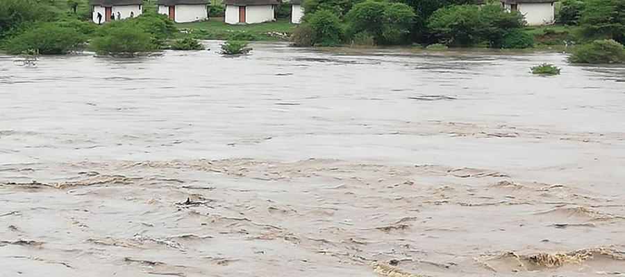
The district is drained by the White Volta and its tributaries the Sissili and the Kulpawn rivers. Flooding by the White Volta is an annual problem caused mainly by the numerous small rivers, which flow into it especially below Pwalugu. Occasional flash floods have also been caused by spilling of waters from streams further up stream in Burkina Faso as happened in the rainy season of 1995.
The prevailing rainfall and the nature of the underlying rock formations determines to a large extent the ground and surface water potential for the district. The present combination of heavy run-off, high evaporation and transpiration and low infiltration rates to recharge aquifers in some areas in the district, contribute to water deficiencies especially to the west of the White Volta, the south around Fio area and eastern parts around Shelinvoya.
Vegetation
The natural vegetation of the district is classified as Guinea Savannah Woodland, composed of short trees of varying sizes and density, growing over a dispersed cover of perennial grasses and shrubs. The climatic conditions, relief features and soil texture which foster water logged conditions (especially in the area west of the White Volta) in the rainy season and draughty soils in the dry season tend to develop a characteristically hardy tree vegetation adapted to long periods of dry spells.
Geological Formation
The Geological formation in the West Mamprusi District is underlain mainly by the Middle Lower Voltaian, which comprises of sandstone, arkose, mudstone and shale. The western part of the district is underlain by the lower Voltaian formation consisting of sandstones and grit. The northern tip is underlain by the Birimian rock formations. Birimian rocks are metamorphosed lavas, which ply Units, schists, tufts and greywacke. Regarding the middle Voltaian, the depth and degree of weathering depends on the litho logy.
Soils and their sustainability for Agriculture
Soils of alluvial origin (savannah glycols) can be found in the major river valleys and drainage courses; these are predominantly in the west of the district along the basins of the White Volta and its tributaries. These soils are deep, fine textured and are well suited for the cultivation of a wide range of crops. The depth of these soils also allows for the use of bullocks and other forms of mechanised farming.
In spite of their potential s soils in this category remain under-utilized due to drainage and flood control problems. On the flat to gentle upland slopes of the eastern parts of the district are found the moderately well drained upland soils developed mainly from Voltaian sandstones. These soils are characterised by deep loamy soils of sand with good water retention capabilities described as moderately well drained.
Their development potential is in the fact that they are well suited for a wide range of crops; although good farming practices especially soil conservation is imperative. These soils are prone to sheet and gully erosion especially under cultivation. If organic materials are not applied regularly to these soils, heavy nutrient leaching will occur. Figure 1.4 below shows the soil characteristics of the district.
Date Created : 12/6/2017 2:11:02 AM


Local Gov Ministry
Int of Local Gov Studies
Ministry of Information
Local Gov Service
Ghana MPs
Ghana Hospitals
NALAG
 facebook
 twitter
 Youtube
 +233 593 831 280
+233 20 230 9497
+233 593 831 280
+233 20 230 9497 0800 430 430
 GPS: GE-231-4383
 info@ghanadistricts.com
 Box GP1044, Accra, Ghana