- Item

GENERAL
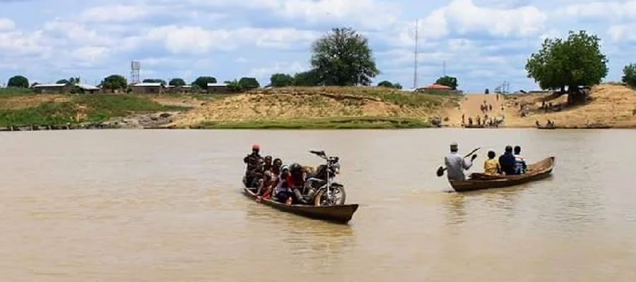
Yunyoo-Nasuan District’s River Network Offers Lifeline for Irrigation, Power and Flood Control
The Yunyoo-Nasuan District is strategically endowed with an extensive drainage system that presents both development opportunities and environmental challenges, placing water resource management at the heart of the district’s growth agenda.
Date Created : 9/18/2025 12:00:00 AM : Story Author : Mary Ayertey/Ghanadistricts.com
The White Volta River, which enters the district from the north-eastern corridor and is later joined by the Red Volta, serves as a major natural drainage feature.Together, these rivers provide immense potential for irrigation farming, water storage and future hydroelectric development, capable of transforming agricultural productivity and livelihoods across the district.
Complementing these are the Nawonga and Moba rivers, which drain the south-western parts of the district and further strengthen its water resource base.
Complementing these are the Nawonga and Moba rivers, which drain the south-western parts of the district and further strengthen its water resource base.
However, the district’s terrain marked by steep rocky hills and narrow valleys contributes to high surface runoff during the rainy season, making some communities vulnerable to flash floods, gully erosion and stream bank degradation. These conditions underscore the need for targeted drainage control measures and climate-resilient infrastructure to protect lives, farmlands and settlements.
As climate variability intensifies, stakeholders are calling for integrated drainage management strategies that will harness the district’s river systems for development while reducing flood risks. With the right interventions, Yunyoo-Nasuan stands poised to turn its natural drainage network into a powerful engine for sustainable development and environmental protection.

GoG Portal
Local Gov Ministry
Int of Local Gov Studies
Ministry of Information
Local Gov Service
Ghana MPs
Ghana Hospitals
NALAG
Local Gov Ministry
Int of Local Gov Studies
Ministry of Information
Local Gov Service
Ghana MPs
Ghana Hospitals
NALAG
 facebook
 X
X
 Youtube
 instagram
 whatsapp
 +233 593 831 280
+233 20 230 9497
+233 593 831 280
+233 20 230 9497 0800 430 430
 GPS: GE-231-4383
 info@ghanadistricts.com
 Box GP1044, Accra, Ghana