Location and Size
Asuogyaman District Assembly is one of the twenty-one(21]districts in the Eastern Region of Ghana it covers a total estimated surface are of 1,507 square kilometers and constitutes 5.7% of the total area of eastern region and making the 10th largest district in the Region with its capital at Atimpoku. The District is one of the forty-five new districts created in 1988 as a result of the Ghana Government’s re-demarcation exercise to operationalise the decentralization programme in the country.
The Asuogyaman District Assembly is one of the twenty-one district in the Eastern Region. It is located approximately between latitudes 6º 34º N and 6º 10º N and longitudes 0º 1º W and 0º14E. It is about 120m above Mean Sea Level (MSL). It covers a total estimated surface area of 1,507 sq. km, constituting 5.7 percent of the total area of the Eastern Region and the 10th largest district in the Region. Lower Manya Krobo District borders the district to the north and the Kwahu West Municipal to the south and west. Asuogyaman is a traditional district situated between the Volta and Eastern Regions and they share borders to the east with Kpando, South Dayi, Ho Municipal and the North Tongu Districts of the Volta Region.
Topology and Drainage
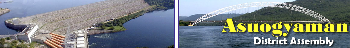
The district relief characteristics are generally undulating with steep slopes in some parts. The district is interspersed with five highlands, which are rocky in nature. The topography of the district is generally undulating.It is a mountainous terrain, rugged and characterized by configuration of several summit and steep slopes of hard sandstones and quartzite ridges many rocks out-crops and scarps. The Volta River cuts through ridges to create a gorge which became ideal for the construction of Volta Dam.The critical area of the Volta gorge is located in the district. The Volta Lake flows through definite channels within the gorge area but spread upstream, after Gyakiti and Boso into a very large lake acclaimed to be the largest man – made lake in the world.
The Lake is heavily braided at Atimpoku as it flows over the low lying areas of the District and begins to meander its way into the sea at Ada. The flow of the Volta through the undulating landscape of the District creates an extensive lakefront good for tourism development.
Climate and Vegetation
The vegetation comprises semi-deciduous forest and wooded savanna, while the soil types are Savanna Greisol and Aluiosols. Asuogyaman lies within the dry Equatorial Climate Zone which experiences substantial amount of precipitation. It has a double maximum rainy season which starts in April with the peak months being June and July .The Asuogyaman District lies within the Dry Equatorial Climate Zone, which experiences substantial amount of precipitation.
The district lies within the Semi - Deciduous Rain Forest and the Coastal Savannah Zones of Ghana. The vegetation is predominantly dry semi – deciduous forest and savannah woodland with re – growth. The natural bio-geophysical environment appears rather vulnerable to farming and other forms of environmental stress. Timber resources are negligible. Tree types that are most wide spread in the district include Palm, Mango, Silk Cotton, Neem and Cassia.
This is characterised by a double maxima rainy season, which reaches its peak period in May – July, and the minor season occurs in the period of September – November. Annual rainfall usually starts in April with the peak month in June and ends in November. The dry season starts in November – December and ends in March. The annual rainfall is between 67m and 1130mm; temperatures are warm throughout t the year with maximum monthly mean of 37.2ºC and a minimum of 21.0ºC. Relative humidity is generally high ranging from the highest of 98% in June to 31% in January.in November. The dry season sets in November through December - January and ends in March.The annual rainfall is between 67-1130 millimetres and maximum temperature is 37.2 degrees Celsius. Relative humidity is generally high; ranging from 98% in June to 31% in January. The Asuogyaman District lies within the semi-deciduous Rainforest and Coastal Savannah Zone of Ghana.
Geology and Soil
The main rock types of the area are quartzite acidic gneiss and schist. These are coarse-grained muscovite and biotite schist and gneiss containing numerous quartz veins. Several out – crops of the rocks are in the area. Soil in the area fall within the Savannah Grecol and Viosols.Upland along the hill slopes, the soils consist mainly of forest littosol and laterites. In the low lying areas along the Volta Lake, the soil type falls within the Savannah Greisol and Aluviosols. These are hydro – morphine soils confined to the large depression and valley bottoms of the Volta river plains.
The soil is greyish, dark red in colour. It is mainly impervious and moderately supplied with nutrients. Because of its structure, the soil is liable to temporary flooding in times of high water levels. Its nutrients status is moderate but to ensure sustained yield of crops it requires the use of fertiliser.
Date Created : 11/29/2017 5:24:24 AM


- District Sublinks
- Other Links
- Other Officers
- Downloads
- Saboba: Compensation 2022

 facebook
 X (twitter)
 Youtube
 +233 593 831 280
 0800 430 430
 GPS: GE-231-4383
 info@ghanadistricts.com
 Box GP1044, Accra, Ghana